Thousand Trails Pacific City, Oregon

Thousand Trails Pacific City, Oregon

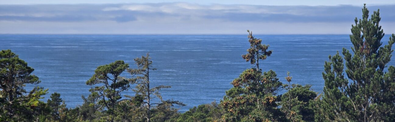
Imagine a 180º view of the Pacific Ocean from a hill 200′ above the water. Well, imagine no more.

We spent eight days at Thousand Trails Pacific City across the street from McPhillips Beach, a vehicle beach in Pacific City, Oregon. That was the view out the back of our RV site.

This is a Thousand Trails (TT) park. If you don’t know TT, we’ll post more about it in the future. Essentially, TTs are campgrounds where anyone can stay for a nightly fee, or if you are a TT member, you can stay for free for up to 21 nights, depending on the type of membership you purchased. Most TTs are near the coast, Great Lakes region, or snowbird locations like Florida, Texas, and Arizona. There aren’t any TT parks in the center of the country.

This park is older but well-maintained, nestled amongst tall, mature evergreens, and has about 300 RV sites. Some sites are full hookups with 50-amp service, but most are 30-amp with only water and no sewer connection. All sites are back in; no pull-through sites. There are 12 or so tree-lined loops with sites spaced throughout. The campground is very hilly, and towing a large RV there is very challenging.  The video to the right begins as we leave check-in and ends when we get backed into our site. It was a slow 30-minute drive from the office to our site, then another 10 minutes to get backed into it.  To shorten the video, I’ve sped it up in places and edited out most of the time we spent pulled over, letting cars pass, or stopped trying to figure out how to negotiate the sharp or narrow turns.  Remember, we’re 60′ long, including the RV and truck, so we can’t take corners too sharply. We’re also 8′ wide, so two RVs can’t pass in opposite directions without someone pulling partially off the road. It was actually close to 45 minutes from the office to our site before editing the video.

We chose a site with a very steep incline at the front but a great view out the back. The truck wheels spun slightly while pushing the RV up the incline as it was so heavy, and the driveway was sand and gravel. Thankfully, Martin was the spotter and navigator; otherwise, I would not have been able to do it by myself. If you have a large rig and travel alone or aren’t confident and skilled behind the wheel, this might not be the park for you. Also, the Ford F-450’s minuscule turning radius, compared to large Chevys, Rams, F-250s, or F-350s, helped tremendously. No other 22′ vehicle has such a great turning radius!

The video above shows a lot of small rocks strewn on the road. There must have been a big storm before we arrived, as the stones had been swept away a day later. The roads in the park aren’t in great shape. Most are paved, but some are dirt or gravel in places, although we didn’t encounter any significant potholes.

TT does not assign you a specific space at check-in; you pick the site you want by driving around and choosing it upon arrival. You let the office know the site number after you’ve parked. At check-in, we were told there is a section, especially for rigs over 38′, near the park’s far end and up the hill. That section also has the best views in the park. We had to navigate sharp turns and narrow roads to get there. Fortunately, we knew the challenges before we arrived and weren’t surprised. It was also helpful that the office staff told us about this section.

We could have stayed at numerous sites throughout the campground. If we had driven around the loops for a while, we might have found a 50-amp site with sewer available, but we opted to go straight to the over 38′ section. This campground is relatively long, narrow, and parallel to the coast highway.

All loops are nicely landscaped and populated with giant fir and cedar trees, many of which are hundreds of years old. Several walking paths through the woods lead to other sections of the park. Penny and Little Bit loved their walks on the trails and roads within the park. They also enjoyed running on the beach, just a short walk across the highway and down a well-maintained trail.

The weather was perfect during our stay, with highs in the low to mid-60s, fog in the morning that usually dissipated by midday, and only light rain once.

Pacific City is tiny and caters to tourists and conventioneers willing to pay for overpriced restaurants. Not our vibe.  Cloverdale is also small but doesn’t seem to cater to anyone, with virtually no restaurants. Tillamook, about 45 minutes away, is rather shabby but has a few decent restaurants and microbreweries that feature Tillamook Cheese in one way or another. After failing to find several restaurants listed on Yelp, we enjoyed an excellent cheeseburger and local brew at Pelican Brewing.

Unfortunately, we didn’t stop at Tillamook Creamery to take the tour and have lunch as their restaurant’s menu was too limited.

Evergreen Coho SKP Park – Chimacum, WA

Evergreen Coho SKP Park – Chimacum, WA

August 2024 was the first time we stayed at Evergreen Coho SKP Park in Chimacum, Washington, and we thoroughly enjoyed it. Chimacum is on Puget Sound’s west side and the Olympic Peninsula’s east side, about 10 miles south of Port Townsend. The weather was fantastic the entire month we were there. Although we only had one day of heavy rain, we had drizzle on several days, which made the temperature perfect. We only had one day when the temperature reached 80° Fahrenheit, and most days were in the 60s—perfect for me!

Chimacum is right on the edge of the Olympic Mountains rain shadow and only gets 29.5 inches of rain a year as opposed to Forks, Washington, just a few hours away, which gets nearly 119 inches of rain, and Mount Olympus, which is even closer and receives a whopping 220 inches a year.

No trip to the Olympic Peninsula is complete without a visit to the Olympic National Park.  Our visit can be found on our post, Olympic National Park and Port Angeles.

We also visited Port Townsend, where we had lunch at Sirens overlooking Puget Sound.  Port Townsend, a town of less than 10,000, is home to over 300 Victorian homes, many of which have been restored.  In the mid-1800s, town planners believed that Port Townsend would become the busiest port in Washington state.  They built for a large influx of people, but that dream came crashing down when Seattle was selected as the railroad hub.

Fort Worden Historical State Park is a short drive from Chimacum and overlooks Admiralty Inlet, the entrance to Puget Sound. Along with Fort Casey and Fort Flagler, Fort Worden was part of the “Triangle of Fire” defense system, designed to protect against sea invasions. The fort was named after Admiral John Worden, who commanded the ironclad warship, the U.S.S. Monitor, during the American Civil War’s Battle of Hampton Roads.  Fort Worden was featured heavily in “An Officer and a Gentleman.”

Evergreen Coho is an SKP Co-op where you can purchase a lifetime lease on an RV plot. This allows you to live there full-time with only an annual maintenance fee. As an Escapee member, we can stay at any Co-op park depending on availability without purchasing a lifetime lease.

Evergreen Coho has a very active social activity calendar.  While we were there, there was a pet parade, an ice cream social, and a nacho and margarita fundraiser to support the landscaping committee, and this didn’t include the crafting and committee meetings.

Our timing coincided with the plum harvest at the RV park, and we enjoyed several plums picked from the park’s colossal plum trees every day. The apples weren’t quite ripe yet.

Our favorite amenity in the park was the well-manicured walking trail through the moss-covered, shaded forest surrounding the park. Penny and Little Bit loved their multiple daily walks along the roughly half-mile, woodchip-covered path that nearly fully encircles the RV park.

While in the park, I utilized their well-stocked woodworking shop to drill holes in five copper busbars for the 48v, 300 amp-hour battery I’m building.  Unfortunately, I could not finish drilling all the holes, so I will have to finish them at a later stop.  There will be a later blog post on the entire project when I finish, likely around March 2025.

One afternoon, we rode our e-bikes through a nearby city park to Indian Island and Marrowstone Island. We intended to visit Kinny Point State Park, but following Google’s direction took us to a dead-end in a neighborhood, and we could not access the park. It turns out that Kinny Point State Park is only accessible via the water. One of the friendly residents of Marrowstone Island told us about the beautiful East Beach County Park about five miles north. This beach was about halfway up to the island’s north end. I didn’t find it that nice, as the beach was covered with smelly, fly-infested, rotting seaweed. It was a 20-mile bike ride, and we barely made it back to the RV park with any juice left in our e-bike batteries.

Olympic National Park
and Port Angeles

Olympic National Park and Port Angeles

Encompassing nearly a million acres, Olympic National Park protects a vast wilderness, thousands of years of human history, and several distinctly different ecosystems, including glacier-capped mountains, old-growth temperate rain forests, and over 70 miles of wild coastline.

We visited Olympic National Park in late August 2024 while staying at the Evergreen Coho SKP Park, Chimacum, Washington. Olympic National Park is very large, and we only visited a small part of its northeast corner not too far from where we were staying.

On the way we stopped at the town of Port Angeles for lunch at the wharf. After lunch we strolled along the City Pier and climbed the newly renovated observation tower. The tower afforded great views of the town and port. After lunch we continued on to the Olympic National Park Visitor Center which is just south of the town.

From the visitor center we drove about 17-miles up the Hurricane Ridge Road to the site of the former Hurricane Ridge Visitor Center which burned down in May 2023. There were restrooms, water, information and maps at temporary buildings in the Hurricane Ridge parking lot.

The day we visited it was sprinkling with rain and cool. Winds can gust over 75 miles an hour on the ridge, so we were grateful that it was a relatively light breeze during our visit. The 45-minute drive from Port Angeles to Hurricane Ridge travels from the lowlands blanketed with old growth forests to treeline, where clumps of subalpine firs give way to open meadows. The day we visited, it was clear enough to enjoy good views of the Olympic Mountains to the south, the highest peak being Mount Olympus.

Hurricane Ridge has a number of hiking trails, from ridgetop traverses to steep trails that descend to subalpine lakes and valleys. We took the short Big Meadow Loop and overlook which climbed the ridge and provided views towards the Strait of Juan de Fuca and Vancouver Island to the North.

Photos of our visit are provided below. Click on the thumbnails to view the photos.

Mount Rainier National Park

Mount Rainier National Park

Mount Rainier National Park was established on March 2, 1899, as the fourth national park in the United States, preserving 236,381 acres including all of Mount Rainier, a 14,410-foot stratovolcano. The mountain rises abruptly from the surrounding land with elevations in the park ranging from 1,600 feet to over 14,000 feet. The highest point in the Cascade Range, Mount Rainier is surrounded by valleys, waterfalls, subalpine meadows, and 91,000 acres of old-growth forest. More than 25 glaciers descend the flanks of the volcano, which is often shrouded in clouds that dump enormous amounts of rain and snow.

We visited Mount Rainier National Park in early September 2024 while staying at Harmony Lakeside RV Park, Silver Creek, Washington. We entered the park at the Nisqually entrance in the southwest corner of the park and drove along the winding Paradise Valley Road through old growth pine forests to the historic Longmire Area.

We parked at Longmire and walked around the historic district where many original park buildings can still be seen. At Mount Rainier, designers selected massive logs and glacial boulders as the building materials best suited for integrating new structures with their natural settings. This style of architecture, known as “National Park Service Rustic”, is on display throughout the Longmire district. This style of architecture became a model for buildings across the National Park Service.

Walking through the Longmire district we reached the historic Longmire Suspension Bridge that crosses the Nisqually River. We walked over the creaky wooden suspension bridge that is the oldest surviving road bridge in Mount Rainier National Park, and one of the few road-bearing suspension bridges in the National Park system. The road bridge was originally built in 1924 using local logs for the suspension towers and bridge structure. Although the logs were replaced with dimensional lumber during later renovations, the bridge still maintains it original design form and appearance.

Continuing on from the Longmire district, we stopped at the Cougar Rock camping and picnic area to enjoy our lunch at a picnic table amongst the old grown pine forest. At this point we were wondering if we would get to see Mount Rainier as the tree tops all around us were shrouded in low-cloud and mist.

Continuing on along the road we visited the Christine Falls, and Narada Falls. The second falls was much taller, fully visible from a view area about a 1/4-mile walk from the parking area.

As we continued along the road, we started to climb out of the pine forest through the low clouds and mist into sub-alpine meadows with colorful seasonal wildflowers. As we rounded one of the switchback bends near the Paradise area, we finally got our first view of the spectacular snow-capped dome of Mount Rainier. We parked at the Paradise area parking lot and walked the short distance to the Henry M. Jackson Memorial Visitor Center and Paradise Inn. There were spectacular views of Mount Rainier and other surrounding mountain peaks from here.

We continued through the Paradise area and proceeded downhill a mile-or-so to Reflection Lake. As its name suggests, the snow-capped peak of Mount Rainier was fully reflected in the lake and offered a spectacular photo-opportunity.

Photos of our visit are provided below. Click on the thumbnails to view the photos.

×
