Niagara Falls

Niagara Falls

We visited Niagara Falls in early July 2025 while staying at the Daisy Barn Campground in Wilson, NY, about 30 minutes away from the falls. The campground is located on the south shore of Lake Ontario.

The falls are within Niagara Falls State Park and are made up of the American Falls and Bridal Veil Falls on one side of Goat Island, and Horseshoe Falls on the other side of the island. It’s a short walk across Goat Island between the two sets of falls. The falls are on the Niagara River which connects Lake Erie to the south and Lake Ontario to the north. The Niagara River is the border between the US and Canada, and there are several bridges near the falls that cross between the two countries. Because of the way the border runs along the river, Horseshoe Falls are located on the Canadian side of the border and are also referred to as the Canadian Falls, whereas the American Falls and Bridal Veil Falls are located on the US side of the border.

After parking in the nearby State Park Lot 2, we walked the short distance to the Horseshoe Falls viewing area. Horseshoe Falls are huge and very spectacular and there was a tremendous amount of spray generated that constantly blew across the viewing area. While the spray was nice and cooling on the hot day we visited, it made taking photographs difficult. We walked around the tip of Goat Island a short distance to the American Falls and Bridal Veil Falls. This set of falls has less water flow than the Horseshoe Falls and the spray that it generated did not blow across the viewing area, so it was a lot easier to take clear photographs. At both sets of viewing areas you are just a few feet from the river, which gives a tremendous sense of the huge volume of water and power of the falls.

It was interesting to see a statue of Nikola Tesla near the falls to memorialize the first ever transmission of alternating current electricity using Tesla’s new alternating current (AC) induction motor. That marked the first long distance commercial use of AC transmission from the Niagara Falls hydro-electric power station to Buffalo. Today, power plants on both the American and Canadian sides of the Falls have the capacity to produce up to 2.4 million kilowatts of electricity.

After visiting the falls, we drove a couple of miles north along the Niagara River to the Gorge Stairs Trailhead. We took the trail down a series of steep paths and stone steps to a trail along the river below two iron bridges, one that is no longer in use, and a newer one that carries road and rail traffic between the US and Canada. The trailhead is located across the street from the Niagara Falls Underground Railroad Heritage Center and Museum. An earlier bridge across the river on this site was considered to be the northern terminus of the Underground Railroad that served as a crossing point for many freedom seekers including Harriet Tubman. The small museum provided some very interesting historical information on the Underground Railroad, and its connections to the Niagara area.

We very much enjoyed our visit to Niagara Falls, one of the most iconic American (and Canadian) natural wonders.

Redwood National and State Parks

Redwood National and State Parks

In 1918 paleontologists wanting to save the Coast Redwoods as a living link to our evolutionary past campaigned nationally to protect the trees. Three California redwoods state parks resulted: Prairie Creek (1923), Del Norte (1925), and Jedediah Smith (1929). To preserve the trees’ natural Coast Range setting and associated plants and animals, Redwood National Park was created in 1968 and expanded in 1978. The national park boundary encircled the three state parks to better protect superlative ancient redwood forests. In 1994 the National Park Service and California Department of Parks and Recreation began managing the parklands cooperatively, aiming to manage the parks the same.

Redwood National and State Parks holds 130,000 acres of forests, rivers, prairies, and rugged coastline, including 40,000 acres of old-growth redwood forests. Today, the Parks’ boundary extends from Crescent City, CA to just south of Orick, CA.

We visited Redwood National and State Parks in October 2024 while staying at the Rambling Redwoods RV Park in Crescent City, California at its northernmost end. We made a couple of visits to the park during our stay. The first visit was to Jedediah Smith State Park near Crescent City. During the second visit we drove most of the length of the park from north to south on the CA-101 with a detour along the Newton B. Drury Scenic Parkway.

Our visit to Jedediah Smith State Park started at the Hiouchi Visitor Center, a short drive from the RV park and just outside Crescent City. At the visitor center we were given printed directions to get to Howland Hill Road, a 10-mile narrow scenic drive which winds through the giant Redwoods and includes numerous pull-outs to allow vehicles to pass, and trailheads along the way, including the Boy Scout Tree Trail , Stout Grove, and Grove of the Titans Trail. Portions of Howland Hill Road were unpaved, but the road was readily passable by any passenger vehicle, although it was so winding and narrow that we rarely exceeded 15 mph along the road. The drive was spectacular, with giant redwoods literally inches from the road on each side, and shafts of light shining dramatically through the tree canopy.

We decided to take the Grove of the Titans Trail about half-way along Howland Hill Road. This trail was completed in summer 2022 to allow sustainable access to a group of ancient redwood trees named for their remarkable shape and size. The grove contains many tall and wide redwoods with complex features and fascinating adaptations. The trail was a 1.5-mile out and back trail with a small loop at the end. There were many awe-inspiring giant trees along this trail and some of the fallen trees were just as spectacular and interesting as the living ones. After our visit to the Grove of Titans, we completed the Howland Hill Road drive back to Crescent City.

For our second trip into the park, we drove the CA-101 most of the length of the park from north to south with a detour along the Newton B. Drury Scenic Parkway. The Scenic Parkway is a 10-mile section of two lane highway that bypasses a section of CA-101 through the heart of the old-growth redwood forest in Prairie Creek Redwoods State Park. North to south, features include numerous trailheads, Big Tree Wayside, Prairie Creek Visitor Center, and Elk Prairie Campground.

As we continued along the Scenic Parkway, we stopped at the Big Tree Wayside area. This is an easy walk to stunning old-growth redwood trees. A viewing platform and interpretive signage was located around the “Big Tree”, said to be one of the oldest in the park with a height estimated to be 286-feet and a diameter of 25-feet. We took a short circle trail next to the big tree that took us through even more spectacular Giant Redwood specimens.

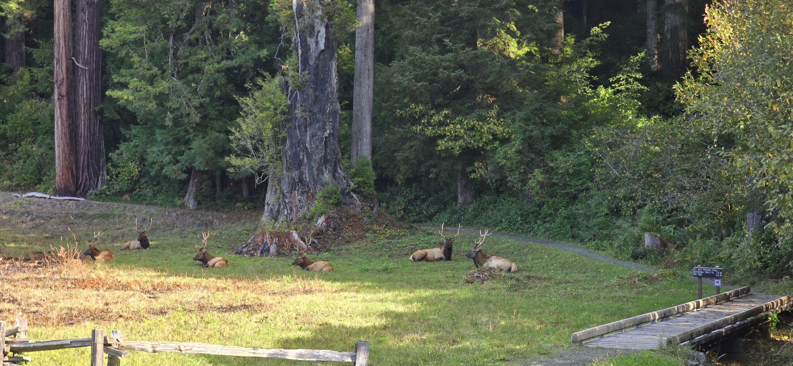
One of the highlights of this visit were the herds of Roosevelt Elk that live around the Elk Prairie area. We were able to watch the Elk as we picnicked at the Elk Meadow picnic area, and then again at the Elk Prairie area a short distance along the scenic parkway. These large Elk were quite majestic as they relaxed in the meadows.

We ended our trip at the Thomas H. Kuchel Visitor Center, located on the Pacific Coast. Exiting the back-door of the visitor center directly onto a sandy beach covered in driftwood, we were met with spectacular views up and down the coast, accompanied by the white breakers reflecting the low afternoon sun.

We really enjoyed our time in the Redwoods. There was a real sense of timelessness amongst trees that have been here for up to 2000 years, and gratitude for the work that has been put-in by the Park Services and others to protect the ancient forests and surrounding areas.

Photos of our visit are provided below. Click on the thumbnails to view the photos.

Evergreen Coho SKP Park – Chimacum, WA

Evergreen Coho SKP Park – Chimacum, WA

August 2024 was the first time we stayed at Evergreen Coho SKP Park in Chimacum, Washington, and we thoroughly enjoyed it. Chimacum is on Puget Sound’s west side and the Olympic Peninsula’s east side, about 10 miles south of Port Townsend. The weather was fantastic the entire month we were there. Although we only had one day of heavy rain, we had drizzle on several days, which made the temperature perfect. We only had one day when the temperature reached 80° Fahrenheit, and most days were in the 60s—perfect for me!

Chimacum is right on the edge of the Olympic Mountains rain shadow and only gets 29.5 inches of rain a year as opposed to Forks, Washington, just a few hours away, which gets nearly 119 inches of rain, and Mount Olympus, which is even closer and receives a whopping 220 inches a year.

No trip to the Olympic Peninsula is complete without a visit to the Olympic National Park.  Our visit can be found on our post, Olympic National Park and Port Angeles.

We also visited Port Townsend, where we had lunch at Sirens overlooking Puget Sound.  Port Townsend, a town of less than 10,000, is home to over 300 Victorian homes, many of which have been restored.  In the mid-1800s, town planners believed that Port Townsend would become the busiest port in Washington state.  They built for a large influx of people, but that dream came crashing down when Seattle was selected as the railroad hub.

Fort Worden Historical State Park is a short drive from Chimacum and overlooks Admiralty Inlet, the entrance to Puget Sound. Along with Fort Casey and Fort Flagler, Fort Worden was part of the “Triangle of Fire” defense system, designed to protect against sea invasions. The fort was named after Admiral John Worden, who commanded the ironclad warship, the U.S.S. Monitor, during the American Civil War’s Battle of Hampton Roads.  Fort Worden was featured heavily in “An Officer and a Gentleman.”

Evergreen Coho is an SKP Co-op where you can purchase a lifetime lease on an RV plot. This allows you to live there full-time with only an annual maintenance fee. As an Escapee member, we can stay at any Co-op park depending on availability without purchasing a lifetime lease.

Evergreen Coho has a very active social activity calendar.  While we were there, there was a pet parade, an ice cream social, and a nacho and margarita fundraiser to support the landscaping committee, and this didn’t include the crafting and committee meetings.

Our timing coincided with the plum harvest at the RV park, and we enjoyed several plums picked from the park’s colossal plum trees every day. The apples weren’t quite ripe yet.

Our favorite amenity in the park was the well-manicured walking trail through the moss-covered, shaded forest surrounding the park. Penny and Little Bit loved their multiple daily walks along the roughly half-mile, woodchip-covered path that nearly fully encircles the RV park.

While in the park, I utilized their well-stocked woodworking shop to drill holes in five copper busbars for the 48v, 300 amp-hour battery I’m building.  Unfortunately, I could not finish drilling all the holes, so I will have to finish them at a later stop.  There will be a later blog post on the entire project when I finish, likely around March 2025.

One afternoon, we rode our e-bikes through a nearby city park to Indian Island and Marrowstone Island. We intended to visit Kinny Point State Park, but following Google’s direction took us to a dead-end in a neighborhood, and we could not access the park. It turns out that Kinny Point State Park is only accessible via the water. One of the friendly residents of Marrowstone Island told us about the beautiful East Beach County Park about five miles north. This beach was about halfway up to the island’s north end. I didn’t find it that nice, as the beach was covered with smelly, fly-infested, rotting seaweed. It was a 20-mile bike ride, and we barely made it back to the RV park with any juice left in our e-bike batteries.

×