Mammoth Cave National Park

Mammoth Cave National Park

Geologists estimate that the oldest part of Mammoth Cave began forming around 10 million years ago. To date, explorers have surveyed and mapped more than 426 miles of cave passage, making Mammoth Cave by far the longest known cave system in the world, with explorers still discovering new passages. Over the course of several million years, underground rivers and streams carved out the underlying limestone creating a vast network of underground passageways.
We visited Mammoth Cave National Park in May 2025 while staying at the nearby Thousand Trails Diamond Caverns RV & Golf Resort near Park City, Kentucky. The Mammoth Cave Railroad Bike and Hike Trail ran alongside our RV park, and we were able to e-bike the 7 miles to Mammoth Cave National Park along this pleasant trail. The entire trail runs 9 miles between Mammoth Cave and Park City.

Mammoth Cave is so huge that the Park offers a total of 10 different cave tours, with at least one scheduled time daily for each tour. Reservations are required for the tours, and the NPS website advises that they often fill up a long way in advance. While most of the tours are guided by a Ranger, we chose to take the only self-guided tour known as the “Extended Discovery Tour”. This tour is available from 10 am to 2:30 pm each day and we were able to get same day walk-up reservations and immediate entry on the Sunday we visited. This tour took us a couple of hours including the hilly walk down to the entrance of the cave from the visitor center. This 1-mile tour covers a Y-shaped section of the cave with some very large passages.  The entry passage ended at a natural “Rotunda” with a historic salt peter mining site.
Saltpetre is a principal ingredient in black gunpowder, and mining saltpetre from the cave was extremely profitable in the early 1800’s and became even more so with the start of the War of 1812. Demand for gunpowder was at an all-time high during the war, as the importation of gunpowder had become very difficult due to the British blockade of many eastern sea ports. The War of 1812 ended in 1815, and the demand for saltpetre fell dramatically. Eventually the mining operation stopped, leaving behind mine workings that can still be seen at the Rotunda.

Huge open passages headed in both directions from the Rotunda. The scale of the cave passages was quite amazing, and the natural “flat roof” of the cave very impressive in its span. Rangers were stationed along the route and answered some of our questions about the cave’s history and its formation. We were struck by the lack of “cave decorations” (stalactites, stalagmites, etc.) in Mammoth Cave, which was quite a contrast from Carlsbad Caverns in New Mexico that we had visited a month earlier. While Mammoth Cave was formed by underground rivers, it is now largely a “dry cave” with its sandstone cave roof preventing water penetration into the cave. Without any water penetration there is no mechanism for the formation of cave decorations which rely on eons of mineral-rich water dripping into the cave through the roof.

We enjoyed our half day visit and were impressed by the spectacular scale of the caves. The self-guided tour we took seemed like a good introduction to the cave system. A multiday visit to the park would be required to take some of the many Ranger-led cave tours that are available.

Photos from our visit to Mammoth Cave National Park are included at the end of this post.

Shiloh National Military Park

Shiloh National Military Park

This is the site of one of the most epic struggle in the Western Theater of the Civil War. Nearly 110,000 American troops clashed in a bloody contest that resulted in 23,746 casualties; more casualties than in all of America’s previous wars combined. Located within the boundaries of Shiloh Battlefield is also a United States National Cemetery, which contains around 4,000 soldiers and their family members.

Congress established Shiloh National Military Park on December 27, 1894, to commemorate the April 6-7, 1862, battle that raged around Shiloh Church and Pittsburg Landing along the Tennessee River. Producing more than 23,000 casualties, the battle was the largest engagement in the Mississippi Valley campaign during the Civil War.


We visited the Shiloh National Military Park in Southern Tennessee in early May 2025 while staying at the Thousand Trails Natchez Trace RV Park in Hohenwald, Tennessee, about a 75-minute drive away. We started our visit at the Visitor Center which told the story of the battle through a variety of media including audio readings of survivor’s memoirs, maps and informational displays, and a video. The battle is named for the Shiloh Meeting House church around which the battle unfolded. A recreation of the Shiloh Meeting House sits on the original church site within the park.

We took the 12.7 mile auto tour route from the Visitor Center, which featured 22 tour stops at such famous places as the Peach Orchard, the Hornet’s Nest, and the Albert Sidney Johnston death site. Informational plaques were posted at each of the stops. An audio tour was also available on the NPS website.

The battle lasted for two days, April 6th and 7th, 1862. During the first day of fighting, Confederate forces made considerable gains, pushing the Union forces back towards Pittsburg Landing on the Tennessee River. The Confederate forces planned to complete a defeat of the Union forces the following day, however Union forces were reinforced early the next morning and conducted an unexpected counter attack, which reversed the Confederate gains of the previous day. The exhausted Confederate army withdrew further south, and a modest Union pursuit started and ended on the second day with a Union victory.

It was interesting to see the spot where the battle started early on the morning of April 6th when a Union scouting party came across Confederate troops at Fraley Field. Along the tour, and within the battlefield in general there are many monuments and monuments, memorials, and troop position markers. Many of the park’s 156 commemorative monuments, 600 troop position markers, and more than 220 cannon were visible from park roads during the auto tour. Some of them could only be reached by hiking into the surrounding woods and fields. We found the section of cannons at “Ruggles Battery” particularly interesting. During the battle more than 50 Confederate cannons formed a 1/2-mile long frontage that was the largest concentration of field guns deployed on a North American battlefield at that time. The auto tour ended at the Shiloh National Cemetery which contains around 4,000 soldiers and their family members. A plaque with the text of Lincoln’s Gettysburg Address at the entrance of the cemetery served as a reminder of the background and significance of the Civil War.

The Shiloh National Military Park was a historically interesting and though-provoking place to visit. We learned a lot and enjoyed touring the now-serene green meadows and woods that mark the site of one of the most significant battles of the Civil War.

Photos from our visit are posted below.

Carlsbad Caverns National Park

Carlsbad Caverns National Park

We visited Carlsbad Caverns National Park in early April 2025 while staying at the SKP Ranch RV Park in Lakewood, New Mexico. When we visited, advance reservations were recommended. This was an easy on-line process that we had done some weeks in advance. As it turned out, the day we visited was not busy and we could easily have got in without an advanced reservation.

We had previously visited Kartchner Caverns State Park near Benson, Arizona in 2024 which we had thoroughly enjoyed, so we had some idea of the type of “cave decorations” and formations to expect. What we did not expect, however, was the sheer scale of Carlsbad Caverns compared to Kartchner. We read that Will Rogers had described Carlsbad Caverns as “The Grand Canyon with a roof over it,” highlighting the cavern’s immense size and unique geological formations. He also added, “it’s got all the cathedrals of the world in it, with half of ’em hanging upside down,” emphasizing the variety and scale of the cave formations. That certainly captures the majesty of the cave quite eloquently.

There are two options for entering/exiting Carlsbad Cavern. We chose to take the “Natural Entrance Trail” down into the cave, and the elevator to leave once we had completed the self-guided cave tour. The 1.25 mile Natural Entrance Trail was quite steep, and consisted of a series of switchbacks as the natural light soon dwindled and we entered the darkness of the cave with sparse lighting highlighting some of the natural features and formations, and providing just enough light to navigate the trail. Overall, this trail loses 750 feet of elevation — equivalent to walking down a 75-story building. This section took about one hour with frequent photo-stops.

The Entrance Trail took us into the “Big Room”, the largest single cave chamber by volume in North America. The trail that loops around the Big Room is is another 1.25 mile trail but this time relatively flat. It took us about another hour or so to walk it.

It’s difficult to describe the extent and variety of cave decorations that you encounter as your walk through the cavern. The magnificent speleothems (cave formations) that continue to grow and decorate Carlsbad Cavern are due to rain and snowmelt soaking through limestone rock, then eventually dripping into a cave below and evaporating. Those water drops have absorbed gases and dissolved minerals from the soil and limestone above. Wherever that water drop evaporates and releases carbon dioxide in an air-filled cave, a small amount of mineral-mostly calcite, is left behind. Thus, drip-by-drip, over the past million years or so, Carlsbad Cavern has slowly been decorating itself.

The slowest drips tend to stay on the ceiling long enough to deposit their mineral there. Common speleothems found on the ceiling may be stalactites, soda straws, draperies, ribbons or curtains. The faster the dripping, the more likely it is to make some type of decoration on the floor. A wide range of decorations on the cave floor include totem poles, flowstone, rim stone dams, lily pads, shelves, cave pools, and of course stalagmites.

A visit to Carlsbad Caverns is highly recommended. It ranks as one of the highlights of the National Parks we have visited to-date. While it’s difficult to capture the scale of the cave in photographs, the gallery below includes some of the many pictures we took that give a glimpse into the cave and its spectacular decorations.

Joshua Tree National Park

Joshua Tree National Park

While the Joshua Tree area has been inhabited by humans for at least 10,000 years, by the late 1920s the development of new roads into the desert had brought an influx of land developers and cactus poachers. Minerva Hoyt, a Pasadena resident who was extremely fond of desert plants, became concerned about the removal of cacti and other plants to the gardens of Los Angeles. Her tireless efforts to protect this area culminated in 825,000 acres being set aside as Joshua Tree National Monument in 1936. As part of the Desert Protection Bill, Joshua Tree National Monument was elevated to National Park status on October 31, 1994. The bill also added 234,000 acres. Elevations in the park range from a low of 536 feet to a high of 5,814 feet at Quail Mountain.

We visited Joshua Tree National Park in late November 2024 while staying at the Thousand Trails Palm Springs RV Park in Palm Desert, California. We entered the park at the Cottonwood entrance at its southeast side, stopping at the small visitor center on the way. Following Pinto Basin Road to Park Boulevard generally took us from the southeast side of the park to the northwest side, eventually exiting at the West Entrance Station.

While we had visited Joshua Tree a number of times over the years, this was our first time driving the full length of the park and we got to appreciate the wide variety of scenery and ecosystems that exist in addition to the famous Joshua Trees that everyone associates with the park. There are three unique ecosystems within the park. As we entered at the southeast side, we found ourselves in the Colorado Desert that was characterized by stands of spike-like ocotillo plants and “jumping” cholla cactus. We stopped at the Cholla Cactus Garden which includes a flat 0.25-mile loop trail. We walked through a section of the thousands of teddy bear cholla cactus with a backdrop of distant mountain views.

As we continued along the road, we passed from the Colorado Desert into the southern boundary of the Mojave Desert which reaches across the northern part of the park. This is the habitat that includes the park’s namesake: the Joshua tree. We stopped at several areas along the road where there were many photo-ops. Along the way we pulled into the Live Oak Picnic area, driving a short distance on dirt roads to a secluded spot among the Joshua Trees and rock formations to enjoy a late picnic lunch as the sun was low in the sky on this short winter day. As we drove out of the park at its northwestern side, we got glimpses of Joshua Tree’s third ecosystem where the Little San Bernardino Mountains provide habitat for a community of California juniper and pinyon pine above 4,000 feet.

Our half-day visit to Joshua Tree was an enjoyable trip through the variety of ecosystems, geological features, and plants to inhabit the park, and we learned there was more to the park than just the eponymous Joshua Tree plants.

Photos of our visit are provided below. Click on the thumbnails to view the photos.


Redwood National and State Parks

Redwood National and State Parks

In 1918 paleontologists wanting to save the Coast Redwoods as a living link to our evolutionary past campaigned nationally to protect the trees. Three California redwoods state parks resulted: Prairie Creek (1923), Del Norte (1925), and Jedediah Smith (1929). To preserve the trees’ natural Coast Range setting and associated plants and animals, Redwood National Park was created in 1968 and expanded in 1978. The national park boundary encircled the three state parks to better protect superlative ancient redwood forests. In 1994 the National Park Service and California Department of Parks and Recreation began managing the parklands cooperatively, aiming to manage the parks the same.

Redwood National and State Parks holds 130,000 acres of forests, rivers, prairies, and rugged coastline, including 40,000 acres of old-growth redwood forests. Today, the Parks’ boundary extends from Crescent City, CA to just south of Orick, CA.

We visited Redwood National and State Parks in October 2024 while staying at the Rambling Redwoods RV Park in Crescent City, California at its northernmost end. We made a couple of visits to the park during our stay. The first visit was to Jedediah Smith State Park near Crescent City. During the second visit we drove most of the length of the park from north to south on the CA-101 with a detour along the Newton B. Drury Scenic Parkway.

Our visit to Jedediah Smith State Park started at the Hiouchi Visitor Center, a short drive from the RV park and just outside Crescent City. At the visitor center we were given printed directions to get to Howland Hill Road, a 10-mile narrow scenic drive which winds through the giant Redwoods and includes numerous pull-outs to allow vehicles to pass, and trailheads along the way, including the Boy Scout Tree Trail , Stout Grove, and Grove of the Titans Trail. Portions of Howland Hill Road were unpaved, but the road was readily passable by any passenger vehicle, although it was so winding and narrow that we rarely exceeded 15 mph along the road. The drive was spectacular, with giant redwoods literally inches from the road on each side, and shafts of light shining dramatically through the tree canopy.

We decided to take the Grove of the Titans Trail about half-way along Howland Hill Road. This trail was completed in summer 2022 to allow sustainable access to a group of ancient redwood trees named for their remarkable shape and size. The grove contains many tall and wide redwoods with complex features and fascinating adaptations. The trail was a 1.5-mile out and back trail with a small loop at the end. There were many awe-inspiring giant trees along this trail and some of the fallen trees were just as spectacular and interesting as the living ones. After our visit to the Grove of Titans, we completed the Howland Hill Road drive back to Crescent City.

For our second trip into the park, we drove the CA-101 most of the length of the park from north to south with a detour along the Newton B. Drury Scenic Parkway. The Scenic Parkway is a 10-mile section of two lane highway that bypasses a section of CA-101 through the heart of the old-growth redwood forest in Prairie Creek Redwoods State Park. North to south, features include numerous trailheads, Big Tree Wayside, Prairie Creek Visitor Center, and Elk Prairie Campground.

As we continued along the Scenic Parkway, we stopped at the Big Tree Wayside area. This is an easy walk to stunning old-growth redwood trees. A viewing platform and interpretive signage was located around the “Big Tree”, said to be one of the oldest in the park with a height estimated to be 286-feet and a diameter of 25-feet. We took a short circle trail next to the big tree that took us through even more spectacular Giant Redwood specimens.

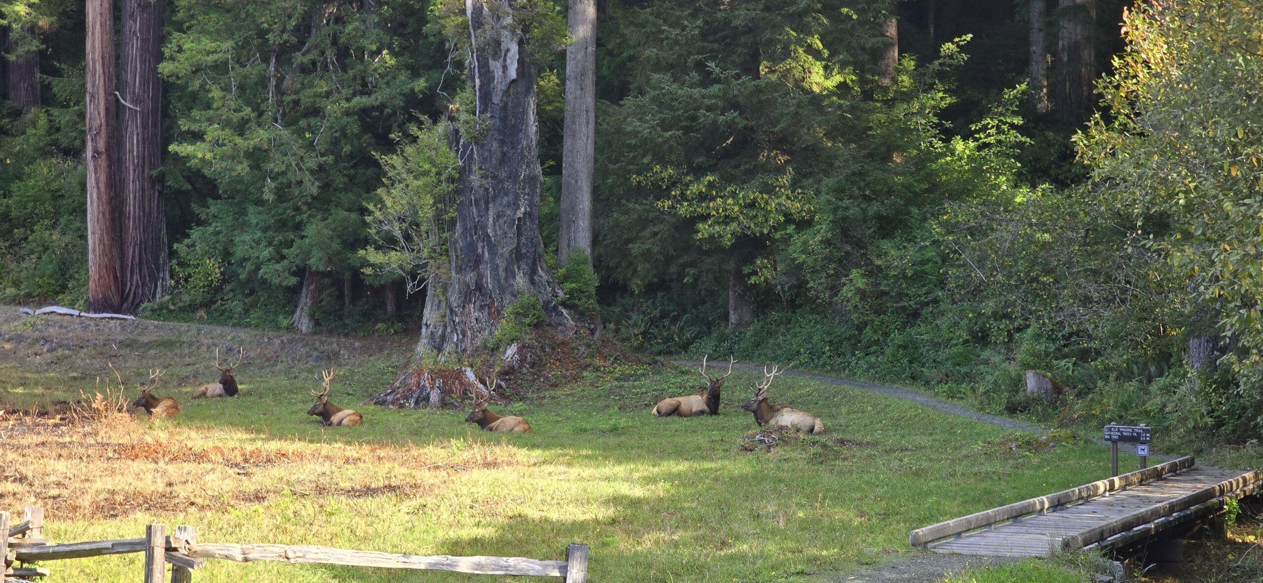
One of the highlights of this visit were the herds of Roosevelt Elk that live around the Elk Prairie area. We were able to watch the Elk as we picnicked at the Elk Meadow picnic area, and then again at the Elk Prairie area a short distance along the scenic parkway. These large Elk were quite majestic as they relaxed in the meadows.

We ended our trip at the Thomas H. Kuchel Visitor Center, located on the Pacific Coast. Exiting the back-door of the visitor center directly onto a sandy beach covered in driftwood, we were met with spectacular views up and down the coast, accompanied by the white breakers reflecting the low afternoon sun.

We really enjoyed our time in the Redwoods. There was a real sense of timelessness amongst trees that have been here for up to 2000 years, and gratitude for the work that has been put-in by the Park Services and others to protect the ancient forests and surrounding areas.

Photos of our visit are provided below. Click on the thumbnails to view the photos.

×