White Sands National Park

White Sands National Park

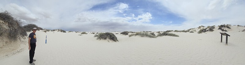
Rising from the heart of the Tularosa Basin is one of the world’s great natural wonders – the glistening white sands of New Mexico. Great wave-like dunes of gypsum sand have engulfed 275 square miles of desert, creating the world’s largest gypsum dune field. White Sands National Park preserves a major portion of this unique dune field, along with the plants and animals that live here.

We visited the White Sands National Park in early April 2024 while staying at the Hacienda RV Resort in Las Cruces, New Mexico about a one-hour drive away.

We stopped at the visitor center at the park entrance and learned about the unique gypsum dunes. Approximately 12,000 years ago, the land within the Tularosa Basin featured large lakes, streams, grasslands, and Ice Age mammals. As the climate warmed, rain and snowmelt dissolved gypsum from the surrounding mountains and carried it into the basin. Further warming and drying caused the lakes to evaporate and form selenite crystals. Strong winds then broke up crystals and transported them eastward. A similar process continues to produce gypsum sand today.

From the visitor center we took the Dunes Drive, an eight-mile out-and-back scenic drive that leads from the visitor center into the heart of the gypsum dune field. Along the road, there were outdoor exhibits, hiking trails, and picnic areas. Our first stop was the Dune Life Nature Trail. This was an easy one mile loop trail that was a great way to experience the dune field, and its typical landscape of sparse shrubs, cacti, and trees. There were informational signs along the loop.

We also visited the Interdune Boardwalk, an elevated boardwalk that leads you through the fragile interdune area to a scenic view of the dune field and the Sacramento mountains. There were extensive information displays along the boardwalk with information on the geology, plants, and animal life of the area.

We tried our hand at sand sledding, one of the most unique things to do in White Sands National Park. We met with little success and came to the conclusion that if you weigh more than the average 12-year-old, the physics of sand sledding are not in your favor!

Visiting Great Sand Dunes National Park was a unique experience. Some areas of the park had very little plant life and the bright white gypsum dunes looked just like snow drifts. Interestingly, the dunes always stay fairly cool even on bright sunny days due to the high water table and reflective sand.

Photos of our visit are provided below. Click on the thumbnails to view the photos.


Saguaro National Park – Tucson, AZ

Saguaro National Park – Tucson, AZ

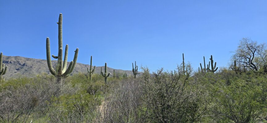
Photograph of a giant saguaro cactusThe saguaro (suh-waa-row), also known as the giant cactus, has been an iconic symbol of the American southwest for ages. These majestic beings are easily recognized by their size and structure, sometimes reaching a height of 50 feet tall. They are native to the Sonoran Desert and do not grow naturally elsewhere.

We visited Saguaro National Park in late March 2024 while staying at the Tombstone Territories RV Resort in Huachuca City, Arizona, about a one-hour drive from the park. The Saguaro National Park has two districts – Rincon Mountain District and Tucson Mountain District – that are separated by the City of Tucson. We visited the Rincon Mountain District on the east side of Tucson, as that was closest to us.

We started our visit at the Rincon Mountain Visitor Center where we were fascinated to learn how long it takes a Saguaro cactus to grow. Branches normally begin to appear when a saguaro reaches 60 to 75 years of age. When a saguaro reaches 35 years of age, it begins to produce flowers. An adult saguaro is generally considered to be about 125 years of age. It may weigh 2 or more tons and be as tall as 50 feet. The average life span of a saguaro is probably 150 – 175 years of age. However, biologists believe that some plants may live over 200 years.

From the visitor center we drove the Cactus Forest Scenic Loop Drive which is a winding paved road that features several trailheads, scenic vistas and pullouts in a total of 8 miles.wide view of numerous ocotillo cactiWe stopped at the Mica View picnic area to enjoy our lunch in the middle of the Sonoran Desert. From the picnic area continued down the scenic drive to the Desert Ecology Trail, a 1/4-mile paved trail with information exhibits along the way about the plants and animals that comprise the Sonoran Desert ecosystem. While the saguaro cactus is the undoubted star of the park, there are a large variety of other plants in the Sonoran Desert. We particularly enjoyed seeing the Teddy Bear Cholla (not nearly as cuddly as its name!), and the elegant ocotillo.

At the southern tip of the scenic loop road, we reached the 1-mile-long Freeman Homestead trail and followed it to the site of an old homestead foundation. There wasn’t much evidence left of the homestead, but the trail was enjoyable and took us through a grove of large saguaros and a desert wash.

Photos of our visit are provided below. Click on the thumbnails to view the photos.

Petrified Forest National Park – Petrified Forest, AZ

Petrified Forest National Park – Petrified Forest, AZ

We made two half-day trips to the Petrified Forest National Park in early November 2023 while staying at the Holbrook/Petrified Forest KOA Journey RV Park, about a half-hour drive from both the south and north park entrances. The Petrified Forest National Park stretches north and south between Interstate 40 and Highway 180. There are two entrances into the park, each one with a visitor center. The petrified log fields are found at the southern end of the park. Outlooks, trails, cultural sites, and painted desert badlands are found in the middle and northern sections.

During both of our visits we drove the full length of the park, southbound on the first trip, and northbound the second time. We stopped at some different overlooks and points of interest each day.

The Painted Desert has a very unique, other-worldly, landscape with colored bands running horizontally through its rolling hills. The colorful Painted Desert badlands are composed of bentonite, a product of altered volcanic ash. The clay minerals in the bentonite can absorb water and swell much as eight times their dry volume. The expansion and contraction properties of the bentonite cause rapid erosion including by preventing much vegetation from growing on—and thus fixing—the slopes of the hills.

There were also views of spectacular mesas and buttes along the park road. Their flat tops are created by the presence of cap rocks, more erosion-resistant rock such as sandstone over softer clays. The softer rock is protected by the cap stones, but, as the sides weather and the protective rock falls down, the softer rock erodes away as it is exposed to the elements. Without the capstone, the feature becomes another rolling badland. Mesas typically are wider than they are tall while buttes are taller than they are wide. Towers, monuments, and hoodoos are even further eroded features.

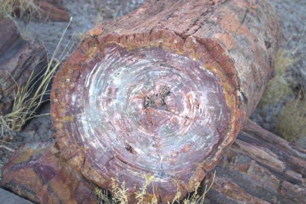
The petrified trees that lie strewn throughout the southern sections of the park are an amazing sight. Initially, looking out over the fields of petrified logs, you might think you are looking at the remnants of recently felled trees, but then you realize that these are actually fossilized trees that are some 200 million years old, and there is a sense that time has stood still in these areas. The quartz within the petrified wood is hard and brittle, fracturing easily when subjected to stress. It is thought that during the gradual uplifting of the Colorado Plateau, starting 60 million years ago, the still buried petrified trees were under so much stress they broke like glass rods. The crystal nature of the quartz created clean fractures, evenly spaced along the tree trunk, giving the appearance today of logs cut with a chainsaw.

Towards the north end of the park, we visited the cultural site of the Puerco Pueblo. A 0.3-mile paved walk winds through the remains of a hundred room pueblo, occupied by the ancestral Puebloan people over 600 years ago. We were able to see Petroglyphs along the south end of the trail, that are still clear and well defined hundreds of years after they were created.

Probably our favorite spot in the park was the Blue Mesa trail, a 1-mile loop descending from the mesa through the hills of the Painted Desert badlands. The loop trail offers the unique experience of hiking among badland hills of bluish bentonite clay as well as petrified wood. We wandered among the hills and petrified logs and were again struck by the timeless quality of the area.

We were able to take the dogs with us on the Giant Logs trail, a 0.4-mile loop behind Rainbow Forest Museum towards the south end of the park. The trail winds around some of the largest and most colorful logs in the park. “Old Faithful”, at the top of the trail, is almost ten feet wide at the base!

Photos of our visit are provided below. Click on the thumbnails to view the photos.

Olympic National Park
and Port Angeles

Olympic National Park and Port Angeles

Encompassing nearly a million acres, Olympic National Park protects a vast wilderness, thousands of years of human history, and several distinctly different ecosystems, including glacier-capped mountains, old-growth temperate rain forests, and over 70 miles of wild coastline.

We visited Olympic National Park in late August 2024 while staying at the Evergreen Coho SKP Park, Chimacum, Washington. Olympic National Park is very large, and we only visited a small part of its northeast corner not too far from where we were staying.

On the way we stopped at the town of Port Angeles for lunch at the wharf. After lunch we strolled along the City Pier and climbed the newly renovated observation tower. The tower afforded great views of the town and port. After lunch we continued on to the Olympic National Park Visitor Center which is just south of the town.

From the visitor center we drove about 17-miles up the Hurricane Ridge Road to the site of the former Hurricane Ridge Visitor Center which burned down in May 2023. There were restrooms, water, information and maps at temporary buildings in the Hurricane Ridge parking lot.

The day we visited it was sprinkling with rain and cool. Winds can gust over 75 miles an hour on the ridge, so we were grateful that it was a relatively light breeze during our visit. The 45-minute drive from Port Angeles to Hurricane Ridge travels from the lowlands blanketed with old growth forests to treeline, where clumps of subalpine firs give way to open meadows. The day we visited, it was clear enough to enjoy good views of the Olympic Mountains to the south, the highest peak being Mount Olympus.

Hurricane Ridge has a number of hiking trails, from ridgetop traverses to steep trails that descend to subalpine lakes and valleys. We took the short Big Meadow Loop and overlook which climbed the ridge and provided views towards the Strait of Juan de Fuca and Vancouver Island to the North.

Photos of our visit are provided below. Click on the thumbnails to view the photos.

Mount Rainier National Park

Mount Rainier National Park

Mount Rainier National Park was established on March 2, 1899, as the fourth national park in the United States, preserving 236,381 acres including all of Mount Rainier, a 14,410-foot stratovolcano. The mountain rises abruptly from the surrounding land with elevations in the park ranging from 1,600 feet to over 14,000 feet. The highest point in the Cascade Range, Mount Rainier is surrounded by valleys, waterfalls, subalpine meadows, and 91,000 acres of old-growth forest. More than 25 glaciers descend the flanks of the volcano, which is often shrouded in clouds that dump enormous amounts of rain and snow.

We visited Mount Rainier National Park in early September 2024 while staying at Harmony Lakeside RV Park, Silver Creek, Washington. We entered the park at the Nisqually entrance in the southwest corner of the park and drove along the winding Paradise Valley Road through old growth pine forests to the historic Longmire Area.

We parked at Longmire and walked around the historic district where many original park buildings can still be seen. At Mount Rainier, designers selected massive logs and glacial boulders as the building materials best suited for integrating new structures with their natural settings. This style of architecture, known as “National Park Service Rustic”, is on display throughout the Longmire district. This style of architecture became a model for buildings across the National Park Service.

Walking through the Longmire district we reached the historic Longmire Suspension Bridge that crosses the Nisqually River. We walked over the creaky wooden suspension bridge that is the oldest surviving road bridge in Mount Rainier National Park, and one of the few road-bearing suspension bridges in the National Park system. The road bridge was originally built in 1924 using local logs for the suspension towers and bridge structure. Although the logs were replaced with dimensional lumber during later renovations, the bridge still maintains it original design form and appearance.

Continuing on from the Longmire district, we stopped at the Cougar Rock camping and picnic area to enjoy our lunch at a picnic table amongst the old grown pine forest. At this point we were wondering if we would get to see Mount Rainier as the tree tops all around us were shrouded in low-cloud and mist.

Continuing on along the road we visited the Christine Falls, and Narada Falls. The second falls was much taller, fully visible from a view area about a 1/4-mile walk from the parking area.

As we continued along the road, we started to climb out of the pine forest through the low clouds and mist into sub-alpine meadows with colorful seasonal wildflowers. As we rounded one of the switchback bends near the Paradise area, we finally got our first view of the spectacular snow-capped dome of Mount Rainier. We parked at the Paradise area parking lot and walked the short distance to the Henry M. Jackson Memorial Visitor Center and Paradise Inn. There were spectacular views of Mount Rainier and other surrounding mountain peaks from here.

We continued through the Paradise area and proceeded downhill a mile-or-so to Reflection Lake. As its name suggests, the snow-capped peak of Mount Rainier was fully reflected in the lake and offered a spectacular photo-opportunity.

Photos of our visit are provided below. Click on the thumbnails to view the photos.

×